ON A WARMING PLANET
Syed Bakhtawar Bilal is a dedicated climate scientist with a specialized focus on drought propagation. Currently based at IIT Mandi, his research delves into understanding the mechanisms, drivers, and impacts of drought propagation, aiming to develop strategies for sustainable water resource management and climate resilience. Through his website, Syed aspires to bridge the gap between researchers and data by providing easy access to valuable resources. Additionally, he envisions the platform as a hub for fostering collaborations, enabling scientists, policymakers, and stakeholders to work together in tackling pressing climate challenges.
HOT TAKES


WHAT THIS WEBSITE OFFFERS


CLIMATE DATA

COLLABORATIONS

This website delivers comprehensive tutorials covering diverse analytical methods and tools, such as R, Python, ArcGIS, HECRAS, AI applications, and advanced hydrological models. These tutorials equip users with practical skills for tackling complex environmental and climate challenges.
This website offers an extensive collection of climate data products, including meteorological, agricultural, and hydrological datasets. Additionally, this website provides high-resolution downscaled data to support localized analysis, enabling researchers and practitioners to address specific climate challenges effectively.
This platform fosters collaborations by offering opportunities to connect with researchers sharing similar interests. This website also provides a space to discuss potential conferences, exchange ideas, and initiate meaningful partnerships, enhancing interdisciplinary efforts in climate and environmental research.
TUTORIALS

ANALYSIS
Detailed assessments and reports on current, historical, and future climate scenarios.
LATEST RESEARCH
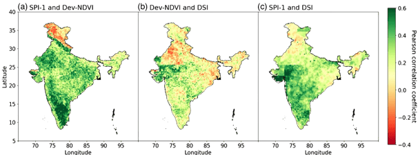
My recent work on drought propagation across India, funded by the Science and Engineering Research Board (SERB) under the Startup Research Grant (Grant Number: SRG/2023/001152), focused on unraveling the intricate linkages between meteorological, agricultural, and hydrological droughts. By leveraging high-resolution spatial datasets, we developed drought propagation metrics to systematically capture how droughts transition and intensify across different sectors. Advanced analyses, including correlation studies, lag assessments, and clustering techniques, were employed to identify key temporal and spatial patterns.


Deciphering the spatial fingerprint of drought propagation through precipitation, vegetation and groundwater
Abstract
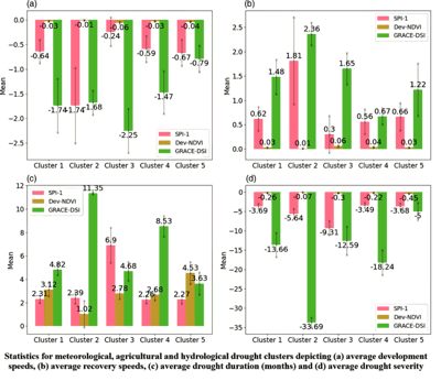
Droughts, depending on their nature, have had devastating consequences, including crop destruction, famine and millions of deaths, particularly in countries like India that heavily rely on rainfall for agriculture. The present study aims to quantify the linkage between meteorological, agricultural and hydrological drought at a high spatial resolution across India. These connections were established by developing various drought propagation metrics followed by subsequent correlation analysis, lag analysis and clustering. Standard Precipitation Index (SPI), Deviation in NDVI (Dev-NDVI) and GRACE Drought Severity Index (GRACE-DSI) were used to represent meteorological, agricultural and hydrological droughts. Run theory with thresholds of −1, −0.5 and −0.05 were used to delineate the drought events for meteorological, hydrological and agricultural droughts, respectively. Furthermore, multivariate K-means clustering based on factors such as drought duration, latitude, longitude, severity, propagation and recovery speeds was done to create spatial clusters having similar drought characteristics. Correlation analysis showed the highest average correlations at a lag of around 7–8 months between meteorological and hydrological drought, a lag of 1–2 months in case of meteorological and agricultural drought and a lag of 3–4 months between agricultural and hydrological drought. The analysis of drought duration indicated that, on average, meteorological drought in India lasted for 2.34 months, while agricultural drought lasted for 3 months, reflecting a 26.5% increase, whereas hydrological drought lasted for 5.22 months, indicating a notable 123% increase. This increase in average drought duration as it propagates from meteorological to agricultural to hydrological drought can be attributed to the lengthening property of drought propagation. Clustering analysis reveals presence of five homogeneous drought clusters. Additionally, cluster analysis reveals that for meteorological and agricultural droughts arid regions showed the highest severity whereas for hydrological droughts north Indian states including Punjab and Haryana showed the highest severity.


RESEARCH COLLABORATIONS
To bring our vision into reality, i seek collaboration with the best partners in the field. I have joined hands with leading research groups specializing in climate studies, hydrology, and data science to achieve comprehensive and impactful results.


CONTACT ME
If you're interested in hearing more about my current research, have a collaborative proposal, or have any other requests, I'd love to hear from you.


